Swiss Public Transit Guide!
After you learn how to use the SBB app, click this link and learn all about the most complicated part of Swiss Public Transit…Multi Bock Stops.
I couldn’t find a single blog or YouTube video on this information before I went and I WISHED someone would have told me.
If you are an American like me and aren’t very familiar with using public transit… you’re in the right place! This is going to have a lot of information and a lot of it might not make sense until you see it in person, but don’t worry we’ll get you where you need to go!
There are 3 main ways to get around in Switzerland. You have the Bus, the Tram, and the Train. Switzerland has one of the best public transit systems in Europe and they are very well known for running on time and the 3 sections work together to make sure you have time to transfer from a bus or tram to a train. You can use google maps when in Switzerland but this will be far less accurate with changes to bus schedules than the official public transit app called “SBB”.
I will cover how to use the app, how to navigate the bus stops on the street, train stations, and purchasing monthly/weekly/daily transit passes!
This is the app Icon. I recommend downloading it now and going through the rest of this page practicing each step on your app.
The SBB app is the MOST accurate for delays, cancellations, and any other public transit info for Switzerland. So I highly recommend checking it if your bus doesn’t come and you’ve only been using google maps.
Once you open the app it will ask to use your current location, make sure to click YES to that. If you are not in Switzerland it will get a little confused because your current location is not near any bus stops but once you arrive to Switzerland it will look like this when you open it up.
You will then see what direction the buses are going. This will name the last stop on that bus line under “direction” as well as the time that it will be leaving from your stop to go that way.
You will notice here that there are some times in RED, this means the bus is running behind. I will break this down more in a minute.
This is showing that the closest bus or tram stop to my location is “Chene-Bougeries, Ch.de L’Eperon”. It then lists all of the upcoming buses that will take me in both directions and the times.
You will see that Bus 1 and Bus 9 both stop at “Chene-Bougeries, Ch.de L’Eperon”.
If you aren’t sure what direction you need to go, you can put your destination into google maps and click the “directions” button. At the top of the screen, it will give you options of car, transit, walking, etc. Click the transit. It will give you some bus/tram/train options.
Once you click on the first transit option it gives you, scroll to where you see the bus/tram number. It will have the direction it is going.
Going back to our SBB app, when I click on these times that are in RED it will take me to this screen. It is showing every stop on that route and how behind schedule the bus is running. It will also warn you if you won’t make your connection or if a bus has been canceled.
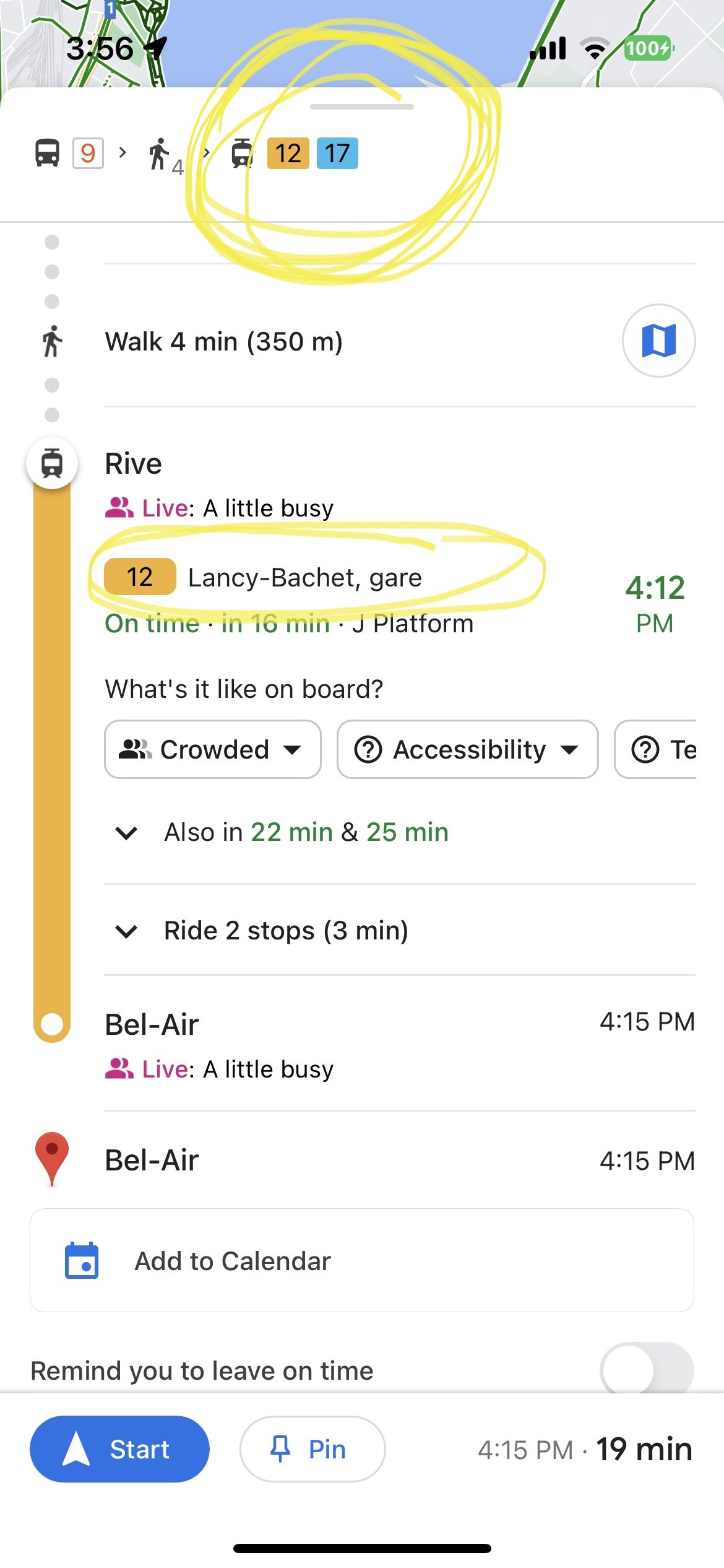
You will see here that Google is showing me that I should take bus 9, walk 4 minutes, and then take EITHER tram 12 or 17, and then when I scroll down it is just showing me the time and route for tram 12.
This is showing me that the bus is 1 minute delayed, but as we’ll see on the SBB app, it’s actually 6 minutes delayed. That big of a delay can easily cause you to miss your connection to your second bus so you might want to look at different options that the SBB app offers.
Another way to use Google Maps to help you best use the SBB app is to determine what bus stop is closest to your final destination. You can open all the Google bus stop suggestions and see what the final stop is. For this example, it is suggesting “Bel-Air”. Once you have that information you can put “Bel-Air” into the SBB app as your destination and it will give you lots of options of how to get there from your current bus stop.
Sticking with our example from Google maps, lets say we are trying to get from our bus stop “Chene-Bougeries, Ch.de L’Eperon” to our destination which is one minute from the “Bel-Air” stop.
I would put “Bel-Air” under “current location” and see what options it gives me.
It’s showing me that I could take bus 1, bus 33, or bus 9.
Next to the picture of the walking figure is a number with an apostrophe. This is telling you how many minutes it will take you to walk to that stop from your location. Notice that bus 33 is a 10min walk, whereas bus 1 and 9 are 2min away.
You will also be able to see how many transfers you will need to make. The open dot indicates that you will need to change buses. For this route, we will have one transfer and it will take a total of 23 minutes to get to our location, including our transfer time.
It shows you what time the bus will arrive at your stop on the left, and what time it will arrive at your final stop on the right. (20:49 departure and 21:10 arrival).
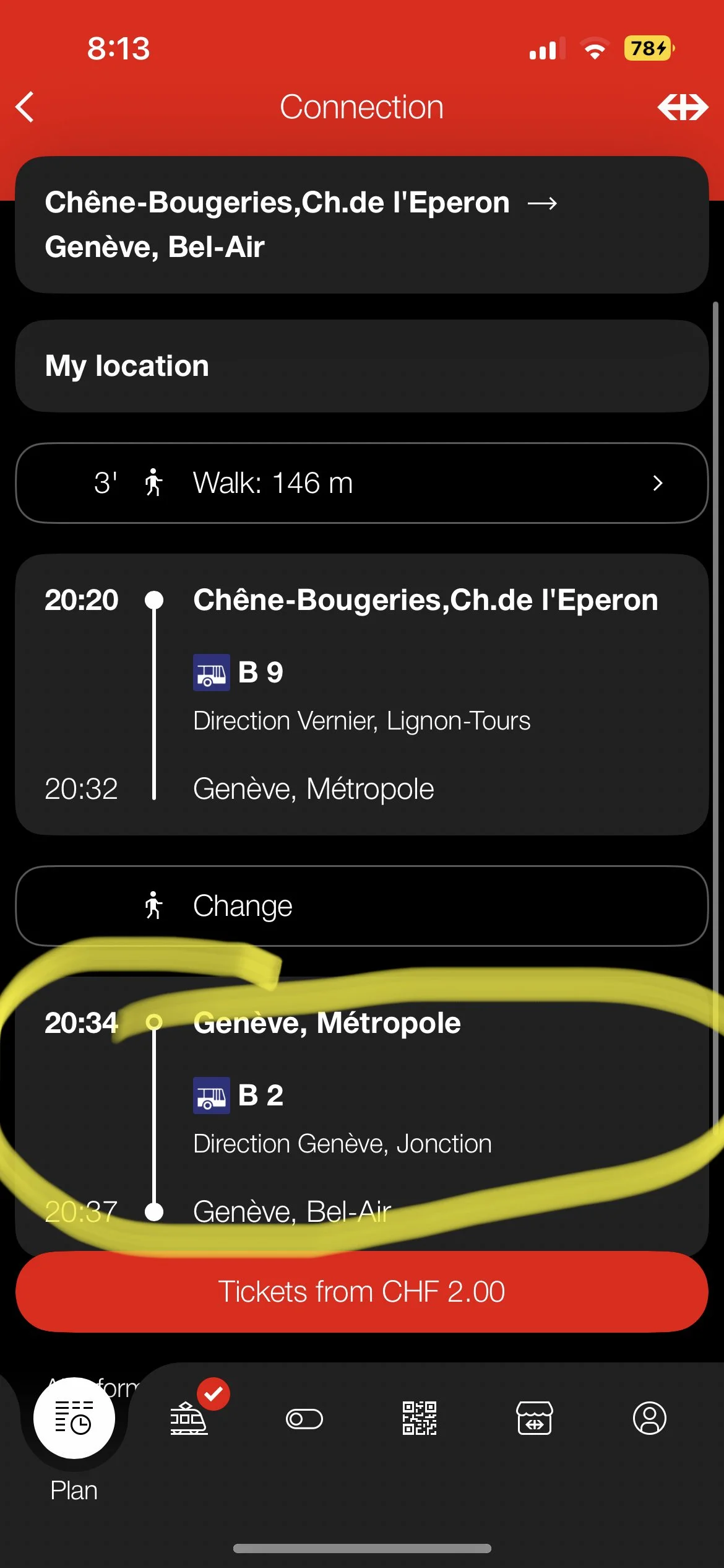
When you click on that route, it will bring you to a screen like this.
This is showing us that we will take bus 9 to the stop “Geneve, Metropole” and then transfer to "bus 2” at the same stop. We will then ride bus 2 for 3 minutes until reaching our final stop.
Sometimes you will need to walk to your transfer bus. If that is the case, where it says the word “change” it will have a number with an apostrophe and a walking picture. This means you will need to walk to that stop.
The second picture shows an example of what that will look like, with an 11min walk to the transfer bus.
But our example shows it is the same stop for both buses. So all you need to do is get off bus 9, and wait there for 2 min until bus 2 comes.
If you want to see exactly what stops you will be going to, you can click on the bus and it will show you every stop and what time it will be at each one.
Let’s review and practice what we know so far before we learn more (can you tell I’m an educator?)
If you know the address of your hotel or other accommodations in Switzerland, put that into Google maps. Then put a destination of somewhere you are planning on visiting (the red cross museum). Find the public transit route and see what it says is your closest transit stop, and the transit stop for your destination.
On the SBB app, plug in your hotel stop into “current location” and the final destination into “to”. See what options it brings up, and how long it will take to get there. Look at the amount of transfers and click on the route to see if you just have to get off one bus and hop on the other, or if you have to walk to the transfer. Check which direction the transit is going because that will come into play in the next section talking about what to do once you’re at the bus stop!
Got it? Sweet, let’s move on!
Let’s finish learning about the SBB app, and then we will learn about multi-block stations and how to read the signs at the actual bus/tram stops, and lastly, we’ll go over train stations and how to purchase tickets and passes at the kiosks!
More SBB features and functions
Once you are on the bus you can check the progress of your route on the app. The red dot will move with the bus so you can see how close it is to your destination. This is very helpful if the screen inside the bus isn’t working so you know when to get off.
If you are wanting to find routes days in advance you will go to your original “plan” screen on the bottom of the page.
Under the section where you put in your bus stops, you will see dates.
After clicking on the dates it will bring you to this screen. You can scroll and pick the day on the left. You can also pick either the time you would like to depart on that day (under departure) or you can click “arrival” to see all the times close to the time you need to be at your destination.
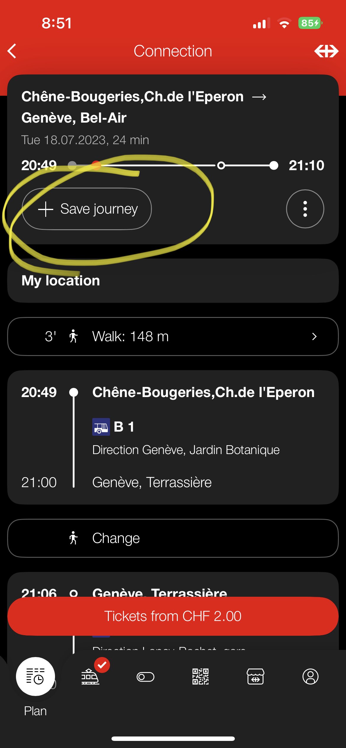
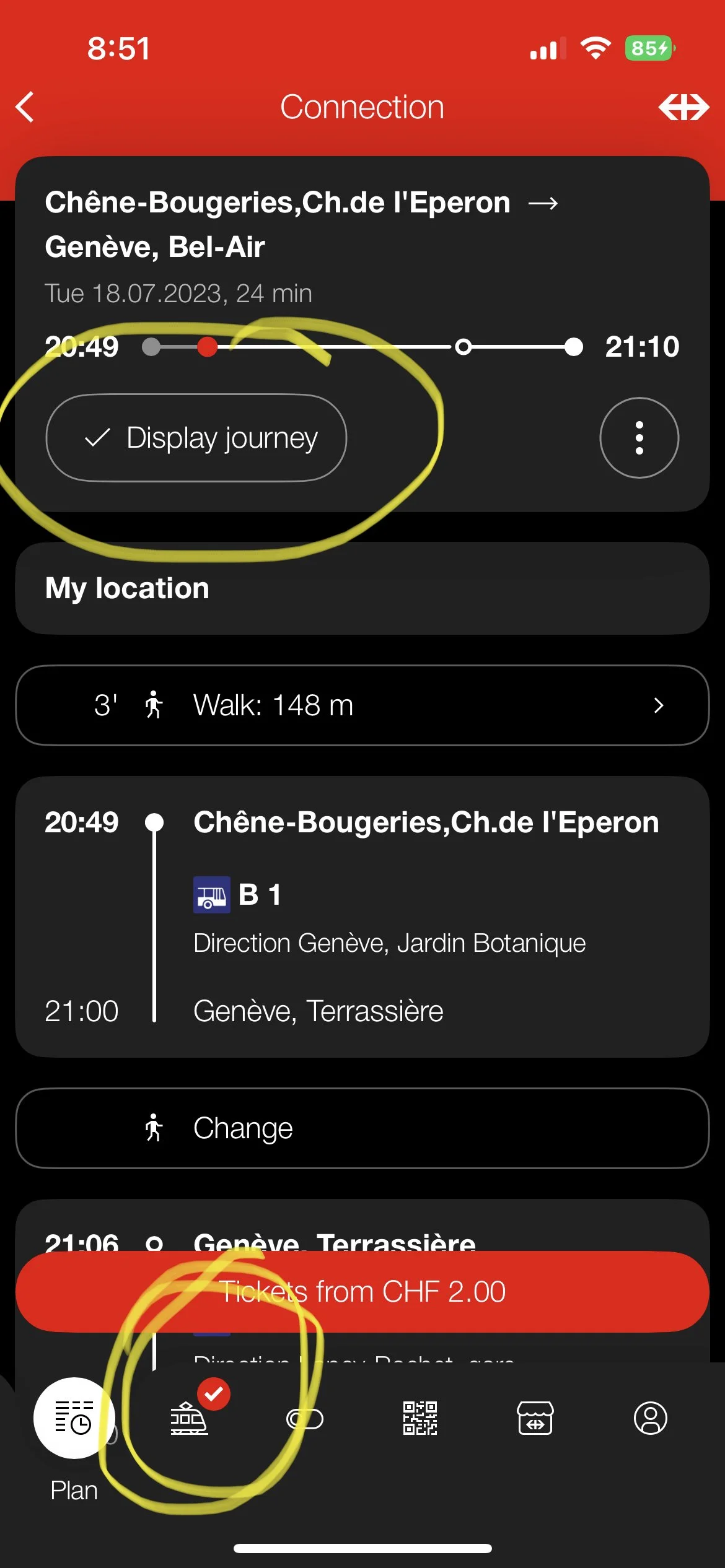
If you are looking at a route for later in the day or week, you can save that route to your account. When you click on the route there will be a “+ save journey” button. Once you click that it will change to “display journey” and a check mark will appear at the bottom of the screen on the train symbol.
To see your saved route go to the bottom of the screen to the train symbol. It will bring you to this screen that shows the route and when it leaves. (This example is showing that the journey is active, but if it is later in the day or week it will tell you the date and time). This is super useful when you are looking up routes in advance so you don’t forget when the one you wanted was.
This is another example of the same screen but with multiple saved routes instead of just one.
To delete a route simply swipe left and click the “delete” button that will pop up.
Here it is giving me all the options on the date I selected that are arriving close to 8am.
Notice that there are direct routes where you don’t have to transfer and others where you do have a transfer. Keep that in mind when planning. Check how many minutes are inbetween the transfer and if you have to walk to the tranfer bus or not. The tricky ones are the multi-block stations like Bel-air, Gare Cornivar, Rive, etc. which we will go over in a moment. If you are transfering from bus 1 to bus 10 at Gare Cornivar they are almost 2 blocks away from eachother and if you have only 2 minutes before the transfer… lets just say unless you are an Olympic track runner you’re not going to make that tranfer and will have to wait a good 10-15 minutes before your next bus arrives.
Another piece of advice: It ALWAYS takes longer to get to your destination than you think it will. You need to remember that this is showing you the STATIONS, your actual destination might still be a good 10minute walk from the closest station. A very common mistake that is made is people look at these and say “it will take me 23 minutes to get there” because that’s how long the bus route is. But you need to also calculate the time to get to your starting bus stop, how long it will take to get from the final stop to your destination, and although Swiss trains are usually on time there can be delays or cancellations that can mess with your plans. I have also missed a bus because my stop was their first stop so the SECOND it turned to the departure time it took off (7:17:00), even though I ran out and the clock still said it was the departure time, I was 30seconds late (7:17:32) and completely missed my connection to a train to Paris. I can also tell you that every single one of my friends from the US who came to see me (8 different people) missed their trains and buses because they did not heed my warning that you HAVE to run early for public transit and plan buffer time for everything. Especially if you are not familiar with the area. I lived in Switzerland for 6 months and knew where 90% of my stops were and was very familiar with the area, and I still missed trains and buses when I went to a new area because google maps is only 70% accurate with the location of bus stops. It goes down to about 10% accuracy if it’s a multi-block stop. So please, for me, and for your own sake… GIVE YOURSELF A 30-45 MINUTE BUFFER!


